AMP: 24
Location: Bridge St and Arlington St, Dracut
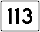
Reassurance shield after Route 113 as we head out of Dracut.

AMP: 24
Location: Bridge St and Emerson Ave, Lowell
A few blocks later, we’ll enter Lowell and Middlesex County.

AMP: 23
Location: Bridge St and VFW Hwy, Lowell
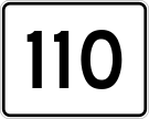
A mile later, as we near downtown Lowell, we’ll approach the Cox Bridge over the Merrimack River into downtown Lowell. 38 won’t use it, though. Turn right to follow the VFW Highway to Route 113.

AMP: 23
Location: Bridge St and VFW Hwy, Lowell
Turn left for 38 south, which follows the VFW Highway eastbound towards Route 110.

AMP: 22
Location: VFW Hwy and Nesmith St, Lowell
A few blocks later, turn right to stay on 38 south as we approach Route 110.

AMP: 22
Location: VFW Hwy and Nesmith St, Lowell
Keep right for 38 south. Keep right to stay on the eastbound VFW, which transitions to Route 110 east.

AMP: 22
Location: VFW Hwy and Nesmith St, Lowell
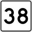
Reassurance shield after exiting the VFW Highway as we approach a rotary.

AMP: 22
Location: VFW Hwy and Nesmith St, Lowell
Turn right for 38 south/110 west, which run concurrently over the Hunts Falls Bridge to Route 133. Stay straight for 110 east.
 S to MA 110/MA 133, N to NH-38/NH State Line
 E to I-93/MA 113, W to MA 38/MA 133